Mount Vernon planners unveil draft 10-year comprehensive plan; zoning changes and infrastructure prioritized
October 09, 2025 | Mount Vernon, Westchester County, New York
This article was created by AI summarizing key points discussed. AI makes mistakes, so for full details and context, please refer to the video of the full meeting. Please report any errors so we can fix them. Report an error »
The plan proposes a shift from the city's current units‑per‑acre approach to floor‑area‑ratio (FAR) controls to regulate building bulk and form rather than only unit counts. Staff said the draft gives broad, neighborhood‑by‑neighborhood examples — low, medium and high density — but does not lock in parcel‑level zoning until the formal zoning update that will follow the plan.
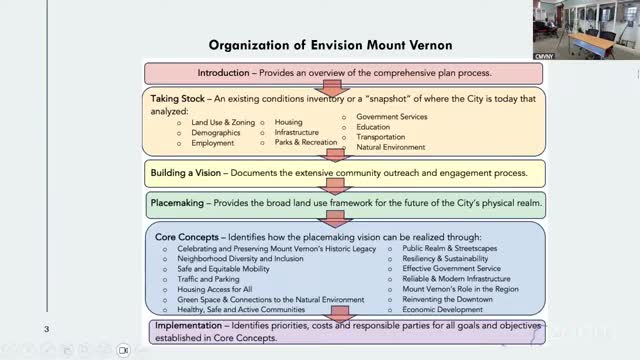
Planners told the board the document is intended as both a long‑range 10‑year vision and a template for implementation. Staff described three linked steps: (1) the comprehensive plan and the “place making” chapter with maps showing generalized low/medium/high density, (2) neighborhood‑level refinement, and (3) adoption of a new zoning ordinance that implements the plan’s rules.
Why it matters: The draft addresses recurring local concerns the city raised during public engagement — flooding and sewer capacity, neighborhood equity, the downtown economy and how to encourage development that improves public realm and pedestrian safety. Staff said the plan is meant to give the planning board clearer, map‑based guidance so consistent decisions can be made on development proposals.
Key elements and next steps
- Density and zoning: The draft uses illustrative ranges (for example, a stated range for “high density” that could encompass mid‑rise buildings near transit) and recommends changing measurement to FAR to control bulk and lot coverage rather than only units. Planners said FAR will better reflect building form across varied unit sizes.
- Infrastructure and resiliency: Staff identified stormwater, sewer and roadway capacity as an urgent constraint. The draft includes resiliency measures such as green infrastructure (rain gardens, tree canopy and permeable features) and a proposed infrastructure/open‑space fund that could collect public or development contributions to pay for off‑site improvements.
- Housing: The plan’s housing chapter outlines strategies to increase housing variety, including ownership pathways and moderate‑income subsidy options. Staff emphasized that subsidy programs could support households earning up to roughly 165% of area median income to preserve middle‑income access in the city.
- Mobility, streets and public realm: Complete streets, bike and pedestrian improvements, and right‑sizing parking rules are integrated across chapters. Planners said transit‑adjacent sites may allow greater intensity while many neighborhood blocks will remain lower density.
- Economic development and vacant city parcels: Staff noted about 15 city‑owned parcels identified as underused assets; they recommended targeted preapproved visions and a rapid approval pathway to encourage catalytic projects.
Public engagement and equity
Staff described an extensive outreach program that included more than 30 meetings across the city, youth engagement and multilingual outreach in Spanish, Portuguese and Haitian Creole. Planners said the process intentionally sought input from seniors, businesses and industrial stakeholders to reflect diverse community needs. The plan includes equity guidance to direct investment to historically underserved neighborhoods rather than concentrating work in a few areas.
Timeline and funding
Staff said the planning board will see zoning work next and that the plan is expected to be adopted by late this year, with zoning and implementation following in 2026. The city received a $75,000 grant from Empire State Development to support the planning effort; staff said additional implementation funding will be sought.
Meeting participants and follow‑up
Planning staff said they will issue an RFP to move from the framework document to detailed zoning and neighborhood implementation work. The board asked staff to supply more specifics on sewer capacity and to document technical findings on stormwater where the draft references changes to impervious area and drainage strategies.
Ending: Staff framed the comprehensive plan as a long‑term, iterative tool rather than a final rule book: the plan provides a map‑based vision and policies, then the zoning code will be drafted to implement that vision. Planners urged continued community input during the public comment period before adoption.
View full meeting
This article is based on a recent meeting—watch the full video and explore the complete transcript for deeper insights into the discussion.
View full meetingSponsors
Proudly supported by sponsors who keep New York articles free in 2025

